Click here for the Weatherlink Monthly summary for June
Warm and wet
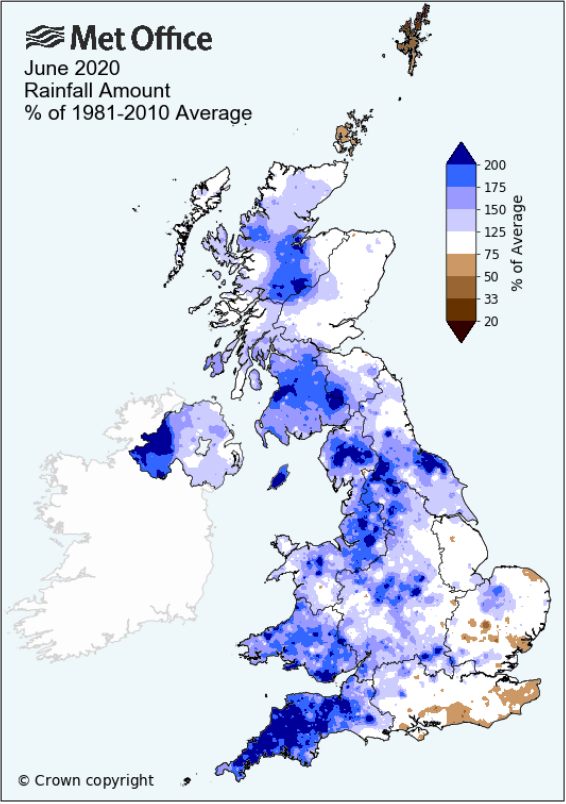
June saw the rain return. In many ways it was a mixed bag - frequent spells of rain or showers, some very warm and sunny days along with a number of cooler days, especially in the first half of the month.
The month saw the very sunny and warm weather of late May continue into the start of June, breaking down through to the 10th as a cool northerly type became established, this bringing showers and/or spells of rain. There was a spell of warm, humid, showery weather 13-18th with a couple of thunderstorms then after a brief cooler interlude there was a hot, sunny spell from the 23rd to 26th. The last few days were cloudy and windy with showers and longer spells of rain, that rain being especially persistent and heavy within the LDNP.
Whilst overall the first half of the month was coolish, the second half saw the temperatures pick up, but rainfall was fairly consistent through the month with blocks of 4-5 days having rain and then only broken by one 1-2 dry days - the thunderstorm on the 16th was short and intense with 20 mm of rain falling in just 15 minutes.
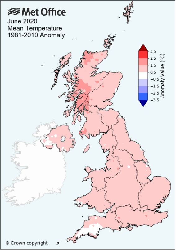
MSLP of 1012.0 Mb was -3.4 Mb below the local average for the month and overall a mean minimum of 9.52°c and a mean maximum of 18.69°c saw the temperature 0.84°c above the eleven year average for this site.
It was the warmest since 2018 and of the twelve now recorded, nine have been colder and two have been warmer - the highest maximum temperature recorded being 27.8°c (25th), the lowest minimum 4.0°c (9th).
Rainfall of 147.9 mm (Crosby Ravensworth School 153.3 mm - Castlehowe Scar 186.9 mm) was 175.6% of average for 2007-19 and made it the wettest June since 2017. Of the fourteen now recorded, ten have been drier and three wetter.
During the month the following was recorded: thunder was heard on four days, with hail on one day (26th). Wind speed averaged 6.77 mph, with a maximum gust of 51 mph (28th).
At the Met' Office site at Newton Rigg, rainfall of 126.0 mm (215%) was the wettest since 2012 and in a series back to 1900, 114 have been drier and six wetter.
A mean temperature of 14.19°c is the warmest since 2018 and in a series back to 1952, 61 have been colder and 7 have been warmer.
With 113.9 mm (194.7% of average) Appleby in Westmorland has had its wettest June since 2017 and its 12th wettest in a record that commenced in 1856 and at Seathwaite Farm it was the 3rd wettest in a record that commenced in 1845.
It goes without saying that rainfall percentages across Cumbria were very high this month with few below 150%; a few sites such as Newton Rigg and Seathwaite (236.2%) being exceptionally high. The final total at Seathwaite of 418.0 mm is the only the sixth time that 400mm has been exceeded in June and it included two remarkable falls of over 100 mm on the 27-28th, a staggering 161.8 mm on the 28th following 100.8 mm 27th.
Figures from the Environment Agency�s rainfall sites were, (figure in brackets being the monthly average for 1961-90) �Data kindly provided by the Hydrometry and Telemetry team of the Environment Agency (Penrith)�:
Kirkby Thore ** mm (42.2 mm)
Haresceugh Castle (Kirkoswald) 109.54 mm (69.3 mm)
Brothers Water 208.7 mm (131 mm) and
Orton (Shallowford) 183.6 mm (86.6 mm [average for 1967-2019])
418.0 mm at Seathwaite Farm (Borrowdale - 177 mm [average for 1981-2010]).
** not available due to faults with the gauge
General Synoptic Report for the Month
The fine weather from the end of May continued into the start of the month with high pressure (HP) ridging down from Norway. This provided for a fine day on the 1st that was warm and sunny throughout and a perfect 22.5°c, but even though the 2nd was even warmer at 23.5°c, cloud bubbled up in the afternoon with the evening becoming overcast.
The fine weather was about to break and now outbreaks of rain would become common-place. Through to the 10th temperatures would be suppressed with a northerly type becoming established, followed by a warmer spell 13-18th, falling away 19th-22nd before another warm spell saw the temperatures become very warm.
However, heavy rain overnight into the 3rd saw 18.3 mm fall and by the 5th we'd had as much rain as in the whole of April and May combined. Low pressure (LP) would now generally dominate, with HP generally absent from the picture until late in the month.
The 4th saw 12.5 mm of rain followed by 12.1 mm on the 5th with temperatures during the 3rd-5th no higher than 13.6°c, courtesy of winds coming from the N-NNW and which were quite brisk at times.
The 6-8th saw temperatures range 15-16°c and it was slightly more settled with sunny intervals before rain arrived overnight into the 10th. The 10th would be a dull and overcast day and along with the 3rd and 5th was the coldest day of the month with a maximum of 13.1°c.
From the 13th the temperatures noticeably increased day on day, rising to 24.2°c on the 15th. LP was surrounding the UK, but which sat in a slack pressure gradient with very light winds. And of course it only takes a few warm days to increase the likelihood of thunder - both the 15-16th started with a hazy sunshine and would then see cloud increasing into the afternoon with the thunderstorms following.
Thunder rumbled from 1520 hrs on the 15th with the downpour (14.3 mm) arriving at 1750 hrs after which the evening became quite misty and sultry. The downpour on the 16th was more notable - thunder from 1320 hrs and quickly followed by a 15 minute torrent from 1340 hrs. In those 15 minutes just over 20 mm fell and had a very impressive rainfall rate of 240 mm at its peak. With further rain during the afternoon the final total was 24.3 mm for the day.
More thunder on the 19th, but which came after a heavy belt of rain in the afternoon. Cooler 21st and 22nd, followed by a brief hot spell with HP over Germany moving in over the UK. From 21.2ۢ on the 23rd, the temperature quickly rose with 27.5°c (24th) and a month's high of 27.8°c (82°f) on the 25th, both days also enjoying copious amounts of sunshine.
The 26th also remained above 25°c, but by now the nights were becoming a little uncomfortable, the 26th starting with a minimum of 14.0°c and the three days of 24-26th were all above 20°c by 1000 hrs, the temperature at 1000 hrs on the 25th being crazily high at 24.0°c.
The breakdown in the weather from the 26th saw LP that had been held at bay by the HP now push in from the SW with troughs ahead of it pushing into the warm air and bringing a brief thunderstorm in the evening of the 26th and which included some hail.
The final few days of the month whilst all remaining above 10°c by night, saw suppressed day-time temperatures, down as low as 13.7°c (28th) and which was quite stormy with outbreaks of rain. The final two days being cool and cloudy.
Rainfall totalled 147.9 mm for the month, with rain recorded on 18 days of which 18 were 'Wet days' (1.0mm +).
The Mean Temperature for the month was 14.11°c -- The Mean Max' was 18.69°c -- The Mean Min' 9.52°c.
We had 0 Air Frosts in the month (year 21) -- Grass Frosts totalled 0 (year 78).
The 1 foot soil temp ranged from a low of 13.7°c on the 11th to a high of 18.6°c on the 26-27th -- with a monthly mean of 15.7°c
The 1 meter soil temp ranged from a low of 11.8°c on the 1st to a high of 14.4°c on the 29th -- with a monthly mean of 12.9°c
This makes the Jan' to June period of 2020 0.85°c warmer than the average for 2009-19 and with 152% of average rainfall for 2008-19
JANUARY 2010
FEBRUARY 2010
MARCH 2010
APRIL 2010
MAY 2010
JUNE 2010
JULY 2010
AUGUST 2010
SEPTEMBER 2010
OCTOBER 2010
NOVEMBER 2010
DECEMBER 2010
JANUARY 2011
FEBRUARY 2011
MARCH 2011
APRIL 2011
MAY 2011
JUNE 2011
JULY 2011
AUGUST 2011
SEPTEMBER 2011
OCTOBER 2011
NOVEMBER 2011
DECEMBER 2011
JANUARY 2012
FEBRUARY 2012
MARCH 2012
APRIL 2012
MAY 2012
JUNE 2012
JULY 2012
AUGUST 2012
SEPTEMBER 2012
OCTOBER 2012
NOVEMBER 2012
DECEMBER 2012
SUMMER 2012
REVIEW OF 2012
JANUARY 2013
FEBRUARY 2013
MARCH 2013
APRIL 2013
MAY 2013
JUNE 2013
JULY 2013
AUGUST 2013
SEPTEMBER 2013
OCTOBER 2013
NOVEMBER 2013
DECEMBER 2013
REVIEW OF 2013
JANUARY 2014
FEBRUARY 2014
MARCH 2014
APRIL 2014
MAY 2014
JUNE 2014
JULY 2014
AUGUST 2014
SEPTEMBER 2014
OCTOBER 2014
NOVEMBER 2014
DECEMBER 2014
WINTER 2014
REVIEW OF 2014
JANUARY 2015
FEBRUARY 2015
MARCH 2015
APRIL 2015
MAY 2015
JUNE 2015
JULY 2015
AUGUST 2015
SEPTEMBER 2015
OCTOBER 2015
NOVEMBER 2015
DECEMBER 2015
REVIEW OF 2015
JANUARY 2016
FEBRUARY 2016
MARCH 2016
APRIL 2016
MAY 2016
JUNE 2016
JULY 2016
AUGUST 2016
SEPTEMBER 2016
OCTOBER 2016
NOVEMBER 2016
DECEMBER 2016
REVIEW OF 2016
JANUARY 2017
FEBRUARY 2017
MARCH 2017
APRIL 2017
MAY 2017
JUNE 2017
JULY 2017
AUGUST 2017
SEPTEMBER 2017
OCTOBER 2017
NOVEMBER 2017
DECEMBER 2017
REVIEW OF 2017
JANUARY 2018
FEBRUARY 2018
MARCH 2018
APRIL 2018
MAY 2018
JUNE 2018
JULY 2018
AUGUST 2018
SEPTEMBER 2018
OCTOBER 2018
NOVEMBER 2018
DECEMBER 2018
REVIEW OF 2018
JANUARY 2019
FEBRUARY 2019
MARCH 2019
APRIL 2019
MAY 2019
JUNE 2019
JULY 2019
AUGUST 2019
SEPTEMBER 2019
OCTOBER 2019
NOVEMBER 2019
DECEMBER 2019
REVIEW OF 2019
JANUARY 2020
FEBRUARY 2020
MARCH 2020
APRIL 2020
MAY 2020
OTHER ARTICLES
The Oldest Inhabitant
An Inch Of Scotch Mist
But it's meant to be Summer (Summer 2017)
© Darren Rogers 2010-20
Want to comment on this site? email